

SDG Indicator 15.3.1: Proportion of land that is degraded over total land area
1. Key features and metadata
Definition: This indicator measures the extent to which land is degraded, which is defined as the reduction or loss of the biological or economic productivity and complexity of rain-fed cropland, irrigated cropland, or range, pasture, forest, and woodlands resulting from a combination of pressures, including land use and management practices. The total area of degraded land is computed using a One-Out All-Out principle in which a significant reduction or negative change in any one of the three sub-indicators (land cover, land productivity and carbon stock) is considered to comprise land degradation (Sims et al. 2021).
| Sub-indicator | Disaggregated by |
|---|---|
|
AG_LND_DGRD Proportion of land that is degraded over total land area (%) |
Land cover class Other spatially explicit land unit |
Sources of information: Data on this indicator is collected and validated by National Focal Points and National Statistical Offices through the United Nations Convention to Combat Desertification (UNCCD) national reporting process every four years. In the absence of, or as a complement to, national data sources, the UNCCD facilitates national reporting through the provision of default data derived from global data sources such as ESA-CCI-LC, SEEA-MODIS, MODIS data products, Copernicus Global Land Service products, Harmonized World Soil Database (HWSD), SoilGrids250m, and Global SOC Map.
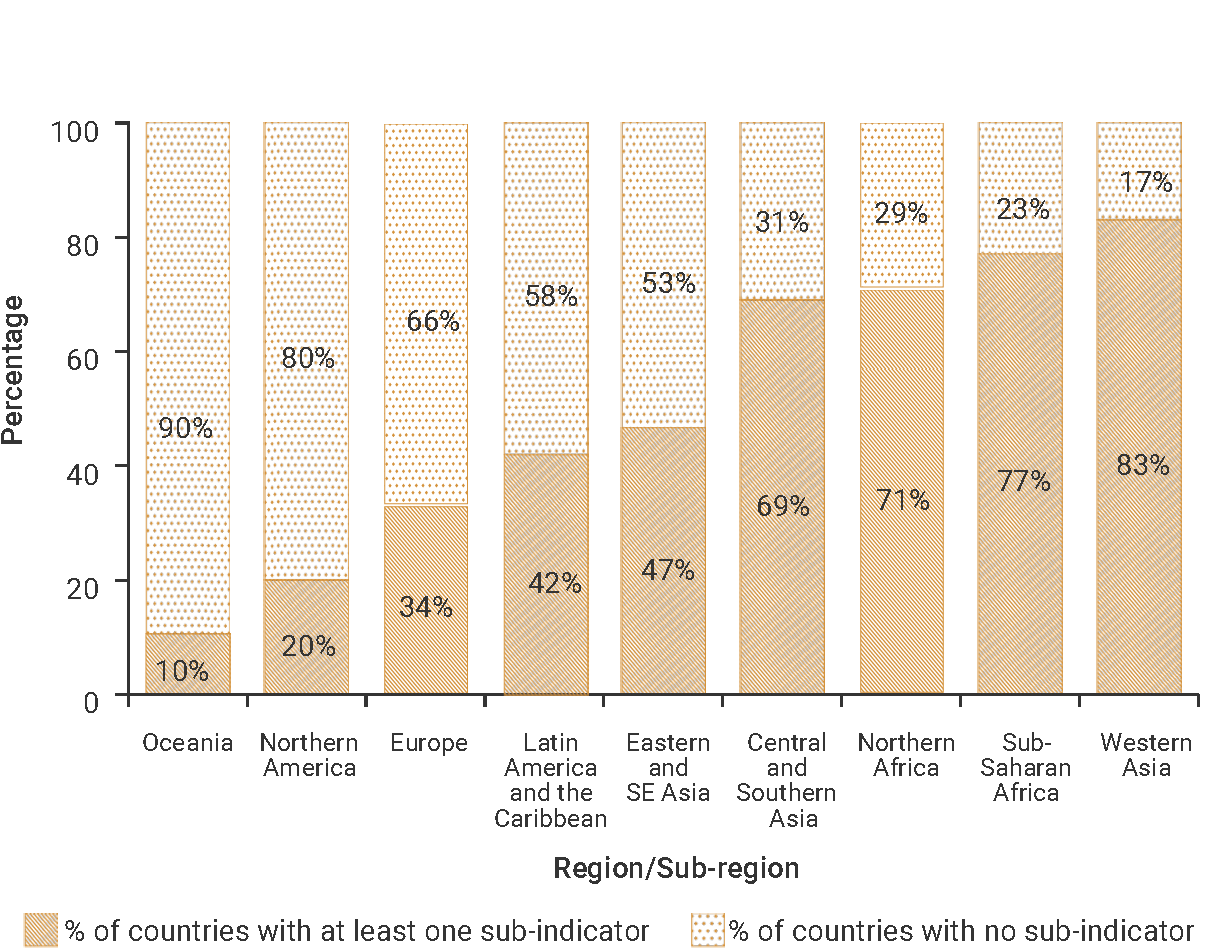
2. Data availability by region, SDG Global Database, as of 02 July 2025
3. Proposed disaggregation, links to policymaking and its impact
| Proposed disaggregation | Link to policymaking | Impact |
|---|---|---|
|
By Land Cover Classification System (%) (IPCC 2019):
Applies to:
|
This disaggregation significantly increases the indicator’s policy relevance by revealing the most affected areas and changes across land cover categories over time resulting from the various factors responsible for land degradation (e.g. the impacts of human activities, climate change or natural events) (United Nations Convention to Combat Desertification [UNCCD] 2022). It helps national authorities to set priorities for a broad range of policy interventions (e.g. sustainable agricultural practices, soil restoration or water management), and could be supportive of responsible land governance and the creation of an enabling environment tostrengthen the implementation of sustainable land management practices. This disaggregation is relevant in the context of the Land Degradation Neutrality (LDN) target-setting programme of the UNCCD (United Nations Convention to Combat Desertification - Science Policy Interface [UNCCD-SCI] 2017). |
This disaggregation can help create new policies that measure actions implemented to support land preservation and reverse current trends of land degradation that benefit affected populations and communities at the local level, especially women, youth and vulnerable people. It can also help improve their living conditions by improving soil productivity and food security; securing access to water and mitigating the effects of drought; supporting the diversification of livelihoods; and significantly reducing the pressure on migration resulting from land degradation and desertification, specifically in drylands (UNCCD 2017). |
|
By ecosystem type (%) (Keith et al.2020): Terrestrial:
Freshwater:
Applies to:
|
This disaggregation helps determine which ecosystem units are considered as degraded (i.e. hot spots and sensitive areas). It also supports the development of targeted policies (i.e. ecosystem-based remedies and land management systems to halt and reverse land degradation) adapted to diverse ecosystem categories and varying local socio-economic circumstances (UNCCD 2022). The LDN conceptual framework also requires that losses due to land degradation are counterbalanced by equivalent gains within the same land type (same ecosystem and land potential) to ensure conservation ofunique ecosystems and to increase the likelihood that there is no net loss in ecosystem services (UNCCD - SCI 2017). Disaggregation by ecosystem typewill show if there are any biases towards restoring certain ecosystem types at the expense of others. This disaggregation is relevant in the context of the UNCCD 2018-2030 Strategic Framework, the Convention on Biological Diversity (CBD) (CBD 1992) Kunming-Montreal Global Biodiversity Framework (GBF) and the United Nations Framework Convention on Climate Change (United Nations Framework Convention on Climate Change [UNFCCC] 1992). |
Implementing interventions based on this disaggregation could reverse current trends of land degradation in a way that benefits affected populations and communities at the local level. It could help improve their living conditions, improve the state of local biodiversity and protect the environment in a sustainable way. It helps identify tailored, converging and nature-based solutions that seek synergies for meeting simultaneously the complex challenges of land degradation, biodiversity preservation and climate change (Global Environment Facility [GEF] 2023). |
|
By agricultural area class (%) (FAO 2021):
Applies to:
|
Agriculture activities and production primarily depend on the well-being of land and soil. They are also affected by the overall trend towards land degradation (FAO 2021). It is therefore critical for policymakers, be it at national or local level, to gather detailedinformation on the breakdown of degraded land by agricultural area class. This information is useful for decision-makers in targeting differentiated actions for crops and grasslands, depending on the observed extent of land degradation. |
This disaggregation can be used as a basis for an assessment of the food vulnerability of countries and communities from the aggravation of land degradation. It points out the risks for agriculture and food security – in particular, the crop and livestock sector. Correlatively, it can be used to prioritize investments in reversing detrimental trends in the agricultural sector, with a view to improving agricultural land productivity, enhancing global food security and increasing the resilience of populations dependent on the land. Hence, it can be used to support the transformation of many traditional and modern food production systems away from agriculture being a major cause of land degradation to being a key agent of land and soil restoration (UNCCD 2022). |